
Open Call Projects
Precision livestock monitoring with AI and IoT tools
PROVATO aims to modernize livestock farming by integrating IoT and AI technologies through edge computing and Non-Geostationary Orbit (NGSO) infrastructure. The project will collect physiological, behavioural, and environmental data using sensors on animals, barns, and smartphones. This information will be combined with external data sources, such as weather services, and processed across edge and cloud layers. The result is meant to give actionable insights and predictive models that will help farmers make informed decisions, improve animal welfare and productivity, and reduce resource use and environmental impact. PROVATO seeks to support the transition to sustainable, precision livestock farming through data-driven innovation.
Key Challenges
- Connectivity in rural areas – Reliable data transmission via LPWAN (e.g., Sigfox)
- Data integration – Combining IoT, weather, and external datasets seamlessly
- Data scarcity – Limited data from relatively few animals and a short observation period
- Data privacy & security – Compliance with GDPR and ethical animal tracking
- Farmer usability – Simple, intuitive dashboards and mobile tools
- Model validation – Reliable predictions across diverse environments
- Team coordination – Effective collaboration across disciplines
Indicative technologies
- Wearable animal collars with sensors (e.g., temperature, motion, GPS)
- Barn and weather monitoring devices (e.g., humidity)
- Smartphones/tablets for additional sensing and data entry
- Sigfox and other LPWAN technologies for low-power data transmission
- Edge gateways for local data aggregation and real-time pre-processing
- Data storage and management engines such as Timescale, InfluxDB, or MongoDB
- Integration with external data sources (e.g., via weather APIs)
- ML toolkits such as scikit-learn, TensorFlow, PyTorch for modeling animal behaviour and stress detection
- Data manipulation and analysis with libraries such as Plotly AI
- Visualization and monitoring using Plotly AI or Grafana, and custom dashboards
- Cloud-based infrastructure (e.g., Docker, Kubernetes) for scalable deployment
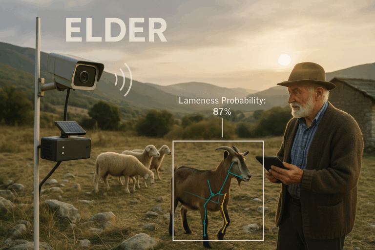
ELDER
ELDER delivers an Edge-AI system for real-time detection of lameness in ruminants. It leverages RGB-D cameras and on-device inference and monitors animal movement without wearables or cloud dependency, making it ideal for remote and rugged farm environments. ELDER analyses gait patterns and delivers lameness alerts through a web interface and empowers farmers to intervene early, improving animal welfare and reducing economic loss.
Key Challenges
- Non-invasive lameness detection without wearable sensors
- Operation under limited connectivity in remote farms
- Adaptation of AI models to environmental variability
- Delivery of real-time, actionable insights to farmers
- Affordable scaling of edge-based animal monitoring
Indicative Technologies
ZED RGB-D cameras
Edge AI Single Board Computer
Computer Vision (pose estimation, gait analysis)
Deep learning frameworks (PyTorch)
Web dashboard for farmers
AGRARIAN SEED-5G NB-IoT infrastructure
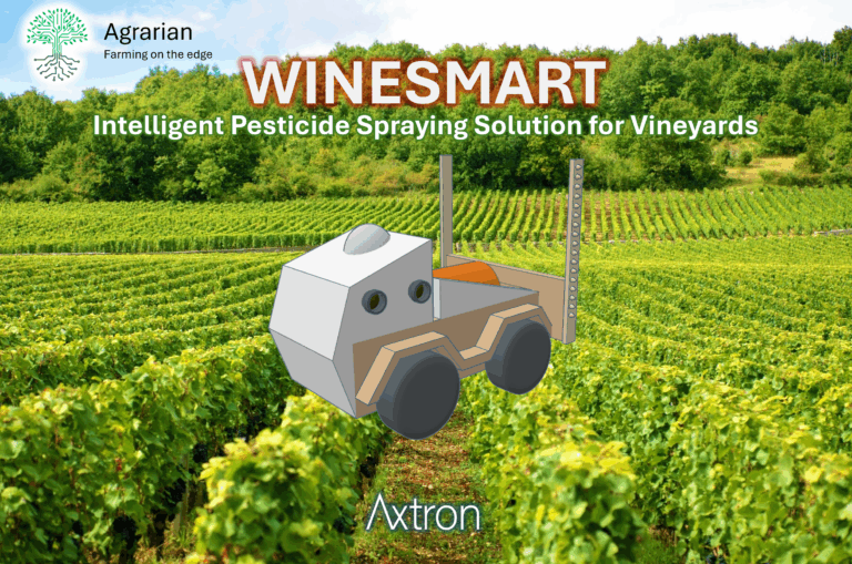
WINESMART
This project aims to build a solution for the intelligent spraying of vineyards, capable of applying the right amount of pesticide only to the exact areas that need it, allowing different amounts of pesticide for different plants and even for different parts of each plant. The solution will be able to create and use high-resolution, high-precision, georeferenced images of vines and grapes, which can be used for early detection of diseases or water stress using AI models. This will allow precise spraying of pesticides only in the areas that need them, with an accuracy of a few centimetres, enabling a substantial reduction in the use of pesticides, without jeopardising their efficiency.
Key Challenges
- Non-invasive lameness detection without wearable sensors
- Operation under limited connectivity in remote farms
- Adaptation of AI models to environmental variability
- Delivery of real-time, actionable insights to farmers
- Affordable scaling of edge-based animal monitoring
Indicative Technologies
- Real Time Kinematics (RTK) GPS: for accurate georeferencing of images
- Convolutional Neural Networks (CNN): AI models for the automatic detection and segmentation of vines and grapes, and signs of disease
- Open Drone Map (ODM): for creating orthophotos and 3D point cloud files of the vineyard
- AGRARIAN dataset: historical data on vineyard climate and soil to train and test algorithms for predicting water stress and disease outbreaks
- Raspberry Pi 4 modules: to control image acquisition and spray nozzles

GrazeSense
GrazeSense is an all-in-one agricultural application designed to enhance livestock and grazing management through innovative technology and smart practices. Exploiting autonomous swarms of drones and advanced vegetation analysis, GrazeSense is capable of scanning large and diverse areas, detecting and analyzing possible grazing lands based on forage quality and environmental conditions, and proposing the optimum pasture option exposed to a web application. It offers real-time actionable insights via a simple and user-friendly platform, delivering focused information, without overwhelming the herd owners with raw data and unnecessary complexity. GrazeSense also integrates complementary features like herd monitoring and animal counting to offer a holistic solution to farmers.
Key Challenges
Identify the real needs of farmers and translate them into system requirements
Create a web application interface friendly to farmers without any technical knowledge
Real-time data transmission from the UAVs to the edge server through the satellite network
Adequate AI and algorithm performance through the satellite link
Platform optimization for edge implementation
Autonomous UAV flight based on the user’s input through the available network
Indicative Technologies
Autonomous Unmanned Aerial Vehicles (UAVs) equipped with cameras
Terrestrial and non-terrestrial communications for UAVs control and data (5G/satellites)
Decision Support System on a application with a simple and user-friendly interface
AI models for data analysis
Edge network implementation

LAVACA
LAVACA project supports Livestock Monitoring and Management general pilot using IoT sensors, GPS, edge computing, and cloud analytics to monitor animals in extensive rural areas. Animals are equipped with devices that collect data on their movement and tracks, temperature, and activity. AI-based models analyze this data to detect anomalies, predict reproductive events, and understand social dynamics within herds. Farmers can access insights via a web interface, enabling real-time tracking, improved animal welfare, and optimized productivity. The system aims at correlating grazing zones with outputs like milk or meat yield, enhancing farm management and productivity through data-driven decisions.
Key Challenges
- Improving animal welfare and farm productivity; Real-time health monitoring and anomaly detection help reduce animal losses, enabling faster response to illness, injury, or stress, and improving overall herd well-being.
- Reducing operational costs; Integration of GPS data and IoT alerts reduces the need for manual monitoring, especially in remote terrains, lowering labor and logistics costs.
- Empowering Farmers with Data-Driven Tools; By combining sensor data, localization coordinates, and ML algorithms, digital tools provide farmers with behavioral models, stress levels, social dynamics tracking, and reproductive event predictions, modernizing livestock management and supporting informed decision-making.
Indicative Technologies
- IoT sensors for monitoring animal metrics (qsensors for temperature, humidity, activity levels, and movements) and GPS positioning for movement patterns
- Edge Computing capabilities for local data processing
- AI/ML algorithm in Python to compute tracks, animal behaviors, and alarms
- SAT communication link combined with LPWAN (Low Power Wide Area Network)

SATVITAI
The project uses CubeSat-like edge hardware and multispectral satellite imagery for real-time vineyard monitoring, focusing on disease detection, vine maturity, and environmental conditions. It aims to enhance data processing efficiency and identify production inefficiencies via AI. An optimized model will detect underperforming areas, tested on Ubotica’s AI Compute Testbed. The model’s performance will be evaluated by speed and accuracy, and results will support improved vineyard management using external data on soil and irrigation.
Key Challenges
- Estimation and prediction of vineyard yield from satellite imagery.
- Feature design and extraction from multispectral data.
- Solution optimization for inference on edge devices that emulate satellite onboard processors
Indicative Technologies
Technologies planned to be used in the project include the accumulation of representative satellite data with Python scripts. Similar scripts will be used for data preprocessing. The AI model will be based on PyTorch building blocks and then converted and optimized with the OpenVINO framework. List:
- Python
- PyTorch
- OpenVINO
- Satellite data repositories, like Sentinelhub
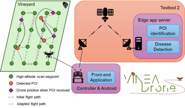
VINEA Drone
VINEA-Drone is a precision viticulture project that uses drones to automate early disease detection in vineyards. A high-altitude multispectral scan quickly identifies areas showing signs of stress or disease and adapts the flight path for targeted inspection. Close-up images are then automatically analysed to detect symptoms. The system includes a mobile app where growers can plan missions, view results, and add their inspection points, making vineyard monitoring easier and more efficient. VINEA-Drone is being developed with grower input to ensure it meets real-world needs and supports sustainable, modern viticulture.
Key Challenges
- Estimating the probability of disease from a high altitude, based on multispectral images
- Detecting vine diseases with high accuracy at an early stage, when symptoms are still mild
- Minimising the flight path and the drone’s energy expenditure while including new points of interest, as they become available
- Robust communications with the satellite testbed, accommodating delays and coverage gaps
Indicative Technologies
- Drones & Autonomous Flight – to scan vineyards quickly and efficiently, minimising manual effort
- Multispectral Imaging – to identify points of interest for closer inspection
- Adaptive Path Planning – to keep the drone flight as short and economical as possible while adapting to newly identified points of interest
- Computer Vision & Machine Learning – to detect vine diseases from images of the plants
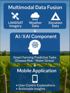
VineSentinel
VineSentinel is an AI-driven decision-support platform tailored for precision viticulture. It features backend services and a mobile app interface that deliver real-time vineyard monitoring and intelligent recommendations. By fusing thermal and multispectral satellite imagery with historical weather, soil-type, and elevation data, advanced AI models infer critical operations such as early disease detection and yield prediction. Built-in explainable-AI techniques ensure that these insights remain transparent and trustworthy. Designed for diverse connectivity environments and varying levels of user expertise, VineSentinel aims to empower vineyard managers, agronomists, and field workers to make data-driven decisions that enhance efficiency, sustainability, and resource optimization.
Key Challenges
Data Quality, Reliability & Ground-Truth Availability
- Accuracy vs. Explainability Trade-offs
- (Rapid) Stakeholder Adoption & Usability Refinement
- Solution Robustness & Field-Ready Deployments
Indicative Technologies
- Geospatial Data Processing & Remote Sensing
- Machine Learning, Deep Learning & Explainable AI
- Mobile Computing, Data Visualization & User Interfaces
Cloud Infrastructure, Backend Services & Storage