Spain /Portugal Pilot

Pilot Leader

Contributors

Vineyards

The pilot focuses on technologies to enhance vineyard management using satellite data, weather information, IoT sensors, and AI models. The goal is to provide vineyard managers with data-driven insights for optimal decision-making. The pilot involves developing AI models for detecting critical information like frost, disease, and irrigation management directly on satellites to enable near-real-time delivery of insights to farm managers. The focus is on deploying edge computing solutions to improve data processing speed and efficiency for time-sensitive agricultural applications.

Pilot's Technology

  • Yield Estimation
    Develop an AI-based model for crop yield prediction using machine learning and remote sensing. By combining satellite data, weather, soil properties, and historical harvests, the model supports scalable, data-driven agricultural planning and food security.​
  • Soil Moisture Monitoring and Forecasting (Aquaview)
    Enable accurate soil moisture monitoring and forecasting through AI and time-series analysis. Integrating past moisture data, weather, and soil characteristics, the system delivers scalable insights for efficient water management across crop types.​
  • Disease Detection and Forecasting
    Develop an AI-powered system for early disease detection and forecasting using onsite data (e.g., photographs, weather) and remote sensing. By analyzing visual symptoms, environmental conditions, and satellite indicators, the model enables the timely identification of crop diseases and supports targeted, data-driven pesticide planning at scale.

Challenges

Data Size and Diversity

Issue: Limited labeled data, particularly for region-specific variations. Mitigation: Augment with public datasets, synthetic data generation, and active learning to prioritize high-value annotations.​

Validation Framework Refinements

Issue: Existing validation methods may not capture spatial, seasonal, or crop/soil-specific variability.​ Mitigation: Introduce cross-season and region-aware validation, including spatial cross-validation and benchmarking against agronomic baselines.​

Data Quality and Consistency​

Issue: Incomplete or noisy field data (e.g., mislabeled photos, inconsistent sensor readings).​ Mitigation: Implement data quality checks, outlier detection, and feedback loops with agronomists for manual review.​

Model Interpretability and Trust

Issue: Stakeholders require transparent decisions, especially in pesticide planning. Mitigation: Integrate explainable AI tools (e.g., SHAP, saliency maps) and provide confidence scores for predictions.​

Scalability Across Regions and Crops​

Issue: Models may overfit to local conditions and not generalize well.​ Mitigation: Use domain adaptation techniques and retrain with region-specific tuning when deployed to new areas.

Open Call Winners on the Pilot

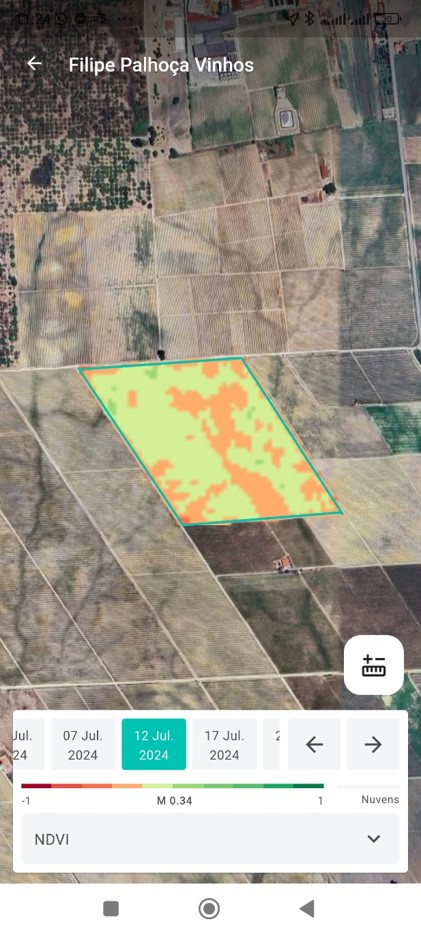
AI-Driven Decision Support for Precision Vineyards

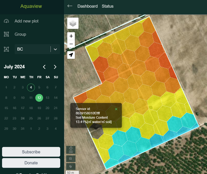
VineSentinel will provide a Crop Field Decision Support System (DSS) that leverages the Thermal & Multispectral EO Dataset (LANDSAT) along with historical weather and land elevation data to generate actionable insights for farmers. The mobile application will serve as the primary interface, allowing vineyard managers, agronomists, and farm workers to visualize satellite-based insights, annotate field observations, and coordinate treatment strategies. This solution is aligned with the pilot 3 goals and will improve implementation of digitalization in vineyards.

Vineyard Inspection and optimised Navigation for Efficient Agriculture using Drones

Today, drones are transforming agriculture by enabling precise crop monitoring, pest detection, and resource management, but their efficiency is constrained by altitude trade-offs. VINEA-Drone addresses this challenge with a cost-effective, semi-automated solution using commercial drones equipped with RGB and multispectral cameras. Its adaptive flight path optimisation allows real-time waypoint integration, ensuring high-altitude scans efficiently detect anomalies, while low-altitude flights capture detailed images at identified points of interest. This proposal will support AGRARIAN data and pilot 3 implementation.

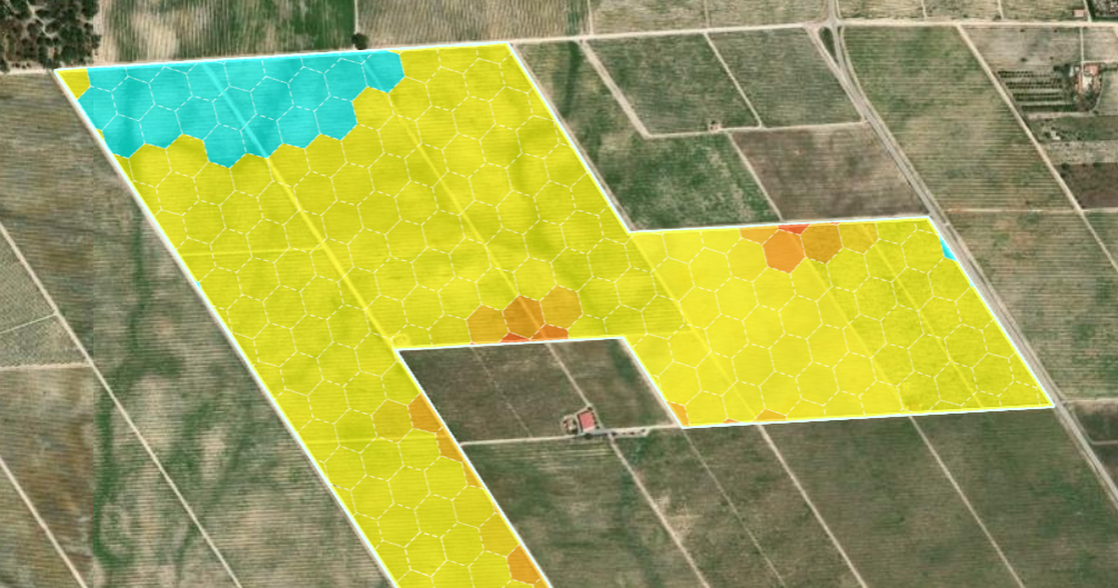
Satellite Edge AI for Precision Viticulture

The project aims to leverage CubeSat-like edge hardware for real-time monitoring and optimal decision-making in vineyards. It addresses vineyard disease estimation, maturity of vines, and environmental monitoring by using multispectral satellite imagery. Enriching the scope of work in Pilot 3, the method will analyze bands and NDVI/vegetation indexes to estimate the maturity of vines and perform, ideally, object detection in search of decreased spread in yield contrary to other parameters like soil moisture, etc. This proposal will enhance data coming from the field and help the farmers and advisors on the best decision.

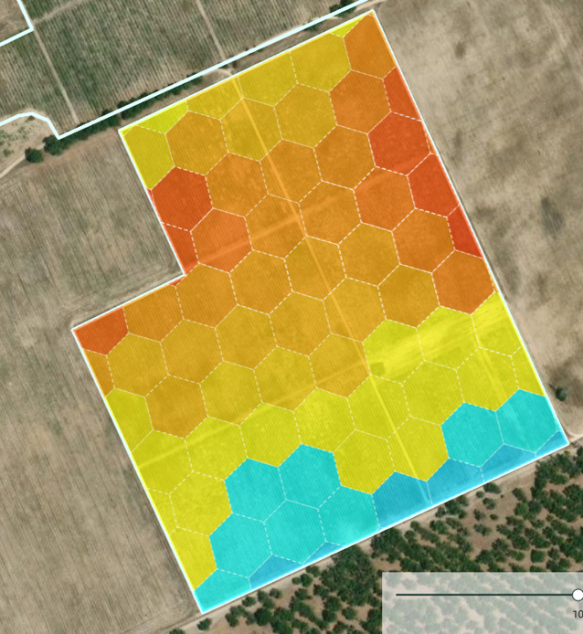
Intelligent Pesticide Spraying Solution for Vineyards

This project aims to build a solution for the intelligent spraying of vineyards, capable of applying the right amount of pesticide only to the exact areas. The solution will be able to create and use high resolution, high precision, georeferenced 3D models and orthophotos of vines and grapes. The project will also create a dataset of high-resolution images of the vineyard, which can then be used to train artificial intelligence (AI) models for the early detection of diseases or water stress. This solution is in line with farm to fork strategy to reduce pesticides in vineyards in Europe.

Results so far

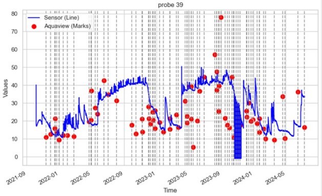
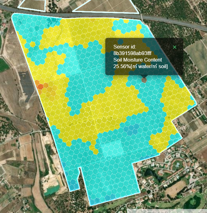
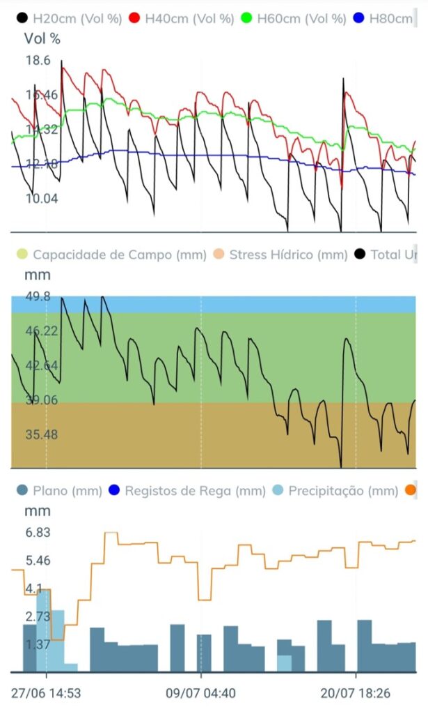
Soil moisture forecasting model performance (ground)

  • 470 Ha from 10 grapevine growers
  • Plots by grapevine variety
  • Yield historical data provided
  • Water status field measurements since June
  • Access to weather stations and soil humidity sensors
Scroll to Top