
Open Call 2 Projects

Agricultural Stress Prediction and Explainability at the Edge
AgriSPEX is a 10-month project that develops an explainable, edge-deployed AI system for early detection of crop stress in Greek kiwifruit orchards. It fuses Sentinel-2 satellite imagery with ground-based IoT sensor data (soil moisture, temperature, humidity) and runs a lightweight Vision Transformer on a satellite edge processor (XE2), delivering compact, human-interpretable stress alerts to farmers within minutes via narrowband IoT links. The project is piloted under the EU-funded AGRARIAN programme’s Testbed 3 infrastructure, to reduce water and pesticide use through timely, transparent decision support.
Key Challenges
- Accurate Stress Detection: Deliver and validate a fused EO+IoT model on kiwifruit parcels, achieving ≥70% F1-score for stress/no-stress classification within 10 months.
- Efficient Edge Deployment: Deploy the quantised/pruned model on the XE2 coprocessor, sustaining ≤80% resource utilisation, ≤200 MB memory footprint, and end-to-end latency under 5 minutes.
- Reliable Compact Alert Delivery: Transmit explainable alerts (≤10 KB) via NB-IoT into AGRARIAN PostgreSQL with ≥95% delivery success and ≥60% bandwidth reduction versus raw image transmission.
- Full AGRARIAN Integration & Open Artefacts: Achieve seamless integration with the AGRARIAN ecosystem and release open documentation and datasets to support reproducibility and reuse.
Indicative technologies
- Tiny Vision Transformer (Tiny-ViT): A quantised and pruned Vision Transformer fine-tuned on Sentinel-2 multispectral imagery, optimised for onboard edge inference on the XE2 coprocessor with ≤200 MB memory footprint.
- Earth Observation and IoT Data Fusion: Integration of Sentinel-2 satellite bands with FARM5.0 ground sensors (soil moisture, temperature, humidity) to disambiguate water stress from fungal onset.
- xplainable AI (XAI) Module: Attention overlays and lightweight surrogate-generated natural-language rationales embedded in each alert, fitting within a ≤10 KB payload budget.
- LEO NB-IoT Edge Transmission: Compact alert delivery over narrowband satellite links with contact-window scheduling, retries, and a two-tier strategy (core alert first, explanation overlay deferred), targeting ≥95% delivery reliability.
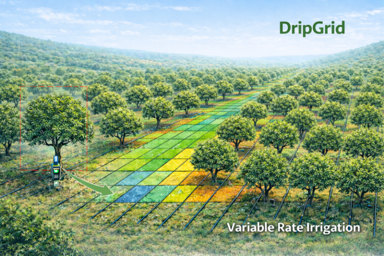
DripGrid: Edge-AI Virtual Moisture Estimation for Dynamic Drip Irrigation Management
DripGrid is an innovative, low-cost precision irrigation solution designed to optimize water use in olive orchards, especially in water-scarce Mediterranean regions. By combining an IoT moisture sensor with satellite data and edge-AI, DripGrid creates a virtual soil moisture map, empowering farmers to implement precise, variable-rate irrigation tailored to the specific needs of their crops. This farmer-friendly system eliminates the need for complex sensor networks, reducing costs while promoting sustainable practices. With simple outputs for valve runtime scheduling and manual dripper adjustments, DripGrid helps prevent over-irrigation and crop stress, increasing yields and saving water.
Key Challenges
- Efficient water management to address water demand variability in orchards amidst water scarcity and climate stress
- Providing a low-cost precision irrigation solution without expensive, dense sensor networks or multi-valve systems
- Ensuring reliable irrigation management in remote areas with limited or no internet connectivity
- Enabling cost-effective VRI implementation with reduced infrastructure costs, making it accessible for broader adoption in rural orchards
Indicative Technologies
Soil moisture sensors for real-time monitoring of soil water content
Weather sensors for local environmental data (e.g., temperature, humidity)
Single Board Computer (SBC) for edge data collection and irrigation control
LEO-based NB-IoT for low-power, wide-area communication in remote areas
Earth Observation (EO) data from satellites (e.g. NDMI)
AI models (e.g. ConvLSTM, LSTM-Tiny, GRU-Lite) for soil moisture virtual sensing
Visualization and monitoring using Plotly AI or Grafana, and custom dashboards
Agri-Precise: Low-Power Precision Positioning Service for Agriculture in Underserved Regions
The Agri-Precise project (a collaboration between the Wireless Networks research lab and a 200-hectare end-user farm) is set to implement and validate a centimeter-level, energy-efficient positioning service tailored for underserved rural areas. By leveraging NB-IoT LEO NTN connectivity and onboard Edge AI, the solution fills a critical gap in reliable data for precision agriculture in places where terrestrial networks don’t reach. The service pairs an innovative Post-Processing Kinematic (PPK) GNSS technique with an AI-powered anomaly detection engine running directly at the satellite edge, providing farmers with dependable, actionable data in near real-time. Within the AGRARIAN framework, Agri-Precise offers the essential spatial context for any high-value farming activity (mechanized or manual) and solves the core issue of data alignment. Without pinpointing the exact location of every measurement, true precision agriculture is impossible. For example, variable-rate fertilizer prescriptions can’t be applied accurately, and crop health data from drones cannot be reliably matched with readings from ground sensors.
Key Challenges
Existing agricultural data streams (e.g., soil sensors, drone imagery) lack a unified, high-precision geospatial reference, making true precision agriculture impossible.
High-precision positioning services often rely on terrestrial infrastructure that is patchy or unavailable in rural areas.
Dealing with NB-IoT bandwidth limitations, managing satellite discontinuous coverage, and running complex algorithms within the strict CPU and memory constraints of the satellite edge.
Drastically reducing power consumption to allow for “deploy-and-forget” hardware. Traditional GNSS and IoT devices are power-hungry, leading to frequent maintenance and battery waste
Existing high-precision solutions are often too expensive for small-to-medium farms.
Ensuring that positioning data is not corrupted or spoofed before it informs automated decision-making systems of AGRARIAN.
Indicative Technologies
NB-IoT LEO NTN for remote connectivity in areas with poor or costly terrestrial coverage.
GNSS post-processing kinematic (PPK) tecnique for high-precision positioning, adapted for edge processing.
Onboard edge AI to execute anomaly detection directly on the satellite.
Smart duty manager that optimizes energy consumption based on SGP4 orbital prediction model.
Containerization to easly deploy the positioning and AI applications.
Any comercial multiband GNSS receiver and NB-IoT module, using the standard RTCM GNSS data format.
PATATERNO: Precision Agriculture for Potato Pest Early Recognition with Non-Terrestrial Communications0
PATATERNO combines commercial drone monitoring with LEO satellite edge computing for potato pest management. Using AGRARIAN Testbed 2’s multi-satellite constellation, the system processes RGB drone video through distributed edge nodes, achieving 90% Colorado beetle detection accuracy while reducing bandwidth requirements by 90%. Weather-aware algorithms prevent the estimated 30% of pesticide applications currently wasted due to rain. The solution targets affordability for small farmers (~€3,000 investment vs €15,000+ for alternatives). Field validation at a 30-hectare potato farm in Campania, Italy, targets 40% yield loss reduction and 30% pesticide decrease, with scalability to Europe’s 1.5 million hectares of potato cultivation.
Key Challenges
Early detection of Colorado potato beetle before crop damage becomes irreversible
Weather-aware pesticide application to maximize treatment efficacy
Enabling real-time agricultural monitoring in rural areas with limited connectivity
Efficient data transmission over satellite links through edge preprocessing
Lightweight AI models capable of running on constrained edge hardware
Transition from calendar-based to need-based pest treatment, reducing costs and environmental impact
Indicative Technologies
- Autonomous Unmanned Aerial Vehicles (UAVs) equipped with cameras
- Terrestrial and non-terrestrial communications for UAVs control and data (5G/satellites)
- Decision Support System on a application with a simple and user-friendly interface
- AI models for data analysis
- Edge network implementation
GRAiZE: Geo-satellite Remote Ai analyZer for livestock hEalth
GRAiZE is an advanced cattle monitoring system based on sensor-equipped collars, designed to enable early detection of health problems in animals raised in remote pastures. The main objectives are: (i) to develop a collar device capable of continuous data collection through integrated accelerometer, temperature, and GNSS sensors, (ii) to classify the animal’s activities and detect deviations in normal patterns and health parameters as early indicators of potential issues, enabling timely interventions and improving animal welfare, (iii) to validate innovative energy-harvesting technologies that provide virtually unlimited autonomy compared to existing solutions.
Key Challenges
- Limited connectivity in remote pastures
- Monitoring over several square kilometers
- Short battery lifetime of existing collars
- Early detection of health anomalies
- Bandwidth optimization to reduce unnecessary communication
Indicative Technologies
- Sensor-equipped cattle collars
- Energy harvesting system
- Remote Aggregator (LoRa-to-SAT gateway)
- AGRARIAN Testbed 1
- Machine Learning models for animal activity classification and health anomaly detection
- Dockerized application
AGRIDRONE: Autonomous UAV-based Data Collection System for Remote Agricultural Monitoring
AGRIDRONE addresses the critical challenge of agricultural monitoring in remote areas where connectivity infrastructure is limited or nonexistent. Many agricultural regions lack reliable telecommunications networks, which prevents continuous data collection and real-time monitoring. Our solution provides an autonomous agricultural data transmission system that uses a UAV to periodically fly over the field, collect raw data from ground sensors, and relay it for analysis. By enabling data retrieval independent of terrestrial connectivity, AGRIDRONE ensures reliable monitoring and decision-making in locations that were previously difficult or impossible to observe continuously.
Key Challenges
- Optimized UAV flight plan in relation to the ground sensors
- Sensors-UAV communication
- Data trasnmission through GEO satellite link
- Energy efficient sensors tranmsission system (wake-up/sleep)
Indicative Technologies
- Autonomous UAV System
- Energy efficient Field Sensors
- Web app
- GEO satellite communications
- Edge Processing
VITISENSE: VITiculture SENSor-based fertilization with AI
VITISENSE aims to transform vineyard fertilization practices through an AI-driven, edge-enabled decision support system for sustainable nutrient management. By combining in-field IoT soil sensors, environmental measurements, and hyperspectral Earth Observation (EO) data, the project delivers near real-time, site-specific fertilizer recommendations tailored to individual vineyard plots. Data streams from soil nutrients, soil conditions, vegetation status, and weather are fused and processed across satellite-based edge and cloud infrastructures, enabling continuous assessment of vine nutritional status.
The core innovation lies in deploying containerized AI models directly on AGRARIAN’s LEO-based Edge AI testbed, allowing onboard inference without dependency on ground-based computing. This architecture provides actionable insights to vineyard operators through the Agricultural Decision Support System (ADSS), translating complex multi-source data into practical field-level recommendations. VITISENSE supports the transition toward precision viticulture by reducing fertilizer overuse in order to improve grape quality, and minimize environmental impact, fully aligned with EU sustainability goals and AGRARIAN’s vision of open, interoperable IoT and Edge AI ecosystems for agriculture.
Key Challenges
Multi-source data fusion: harmonizing heterogeneous IoT, EO, and environmental datasets in near real time using historical data series from pilot activities.
Edge AI deployment: running containerized models onboard satellites with limited compute and energy resources.
Model robustness: ensuring accurate nutrient status predictions.
Data scarcity and variability: scarcity of labeled field data and significant seasonal fluctuations influencing vine condition and nutrient uptake
Data privacy and compliance: GDPR adherence, FAIR data principles, and transparent data governance.
Field validation: demonstrating measurable gains in fertilizer efficiency.
Indicative Technologies
IoT soil sensors (temperature, humidity, electrical conductivity).
Near-surface environmental monitoring – meteorological station (temperature, humidity, precipitation, PAR, wind speed/direction ).
Hyperspectral Earth Observation imagery for vegetation status assessment (if available).
LEO-based NB-IoT communication testbed for low-power data transmission.
Edge AI modules deployed onboard satellite infrastructure for real-time inference.
Containerized AI applications (Docker-compatible) for portability and orchestration.
Central Data Storage integrated with AGRARIAN’s Agricultural Decision Support System (ADSS).
ML frameworks such as PyTorch, TensorFlow, or scikit-learn for nutrient status modeling.
Data fusion and analytics pipelines for spatio-temporal vineyard analysis.
STAR-HERD: Satellite-Testbed Aerial Reasoning with Edge Multimodal LLM
STAR-HERD develops and validates a practical, edge-first drone monitoring system for remote, low-connectivity environments. Processing runs on board the drone (off-cloud), generating compact event messages instead of high payload streaming, while reducing bandwidth needs and improving resilience during intermittent links, as a result, with communication designed for NGSO/LEO-based connectivity. The project is demonstrated through an agriculture/livestock pilot use case and validated using an NGSO/LEO-emulated test environment, including handovers and disruption/recovery scenarios. Over the project duration, STAR-HERD delivers a deployable package, structured data outputs, and a repeatable evaluation protocol, reporting measurable KPIs for latency, delivery reliability, payload efficiency, recovery, and integration readiness.
Key Challenges
Link variability: handover, outages, latency
On-board constraints: compute, power, thermal limitations
Data & labelling quality: noise, occlusion, ground truth
Reliable event delivery: buffer/retry, loss control. Integration & reproducibility: CDS/schema stability, containerisation, repeatable tests
Indicative Technologies
Drone/UAV platform: with on-board (off-cloud) edge processing.
On-board monitoring workflow: event detection & dataset ingestion pipeline.
Compact event messaging: bandwidth-efficient event/alert transmission.
NGSO/LEO emulation testing: handover, routing variation, disruption/recovery.
Ground-side user application: event monitoring, review, and operator interaction.